- Chronology
- Before 1500 BCE
- 1500 BCE to 500 BCE
- 500 BCE to 500 CE
- Sixth to Tenth Century
- Eleventh to Fourteenth Century
- Fifteenth Century
- Sixteenth Century
- Seventeenth Century
- Eighteenth Century
- Nineteenth Century
- Twentieth Century
- Twenty-first Century
- Geographic Area
- Africa
- Caribbean
- Central America
- Central and North Asia
- East Asia
- North America
- Northern Europe
- Oceania/Australia
- South America
- South Asia/South East Asia
- Southern Europe and Mediterranean
- West Asia
- Subject, Genre, Media, Artistic Practice
- Aesthetics
- African American/African Diaspora
- Ancient Egyptian/Near Eastern Art
- Ancient Greek/Roman Art
- Architectural History/Urbanism/Historic Preservation
- Art Education/Pedagogy/Art Therapy
- Art of the Ancient Americas
- Artistic Practice/Creativity
- Asian American/Asian Diaspora
- Ceramics/Metals/Fiber Arts/Glass
- Colonial and Modern Latin America
- Comparative
- Conceptual Art
- Decorative Arts
- Design History
- Digital Media/New Media/Web-Based Media
- Digital Scholarship/History
- Drawings/Prints/Work on Paper/Artistc Practice
- Fiber Arts and Textiles
- Film/Video/Animation
- Folk Art/Vernacular Art
- Genders/Sexualities/Feminisms
- Graphic/Industrial/Object Design
- Indigenous Peoples
- Installation/Environmental Art
- Islamic Art
- Latinx
- Material Culture
- Multimedia/Intermedia
- Museum Practice/Museum Studies/Curatorial Studies/Arts Administration
- Native American/First Nations
- Painting
- Patronage, Art Collecting
- Performance Art/Performance Studies/Public Practice
- Photography
- Politics/Economics
- Queer/Gay Art
- Race/Ethnicity
- Religion/Cosmology/Spirituality
- Sculpture
- Sound Art
- Survey
- Theory/Historiography/Methodology
- Visual Studies
In 1987, when the first volume (Cartography in Prehistoric, Ancient, and Medieval Europe and the Mediterranean) of the History of Cartography series was published, the study of maps was a much different field than it is today. At the biennial International Conference on the History of Cartography, organized by the map-history journal Imago Mundi, presentations by dealers, collectors, and specialists in geography far outnumbered those from scholars in the humanities. The relationship between art history and mapmaking was only beginning to be seriously explored, most notably by Juergen Schulz (“Jacopo de’ Barbari’s View of Venice: Map Making, City Views, and Moralized Geography Before the Year 1500,” The Art Bulletin 60 (1978): 425–74) and Svetlana Alpers (in the chapter “The Mapping Impulse in Dutch Art” from her The Art of Describing: Dutch Art in the Seventeenth Century [Chicago: University of Chicago Press, 1983]). Period maps appeared sparingly in texts, and access to them in libraries and archives demanded travel and persistence. André Thevet, Christopher Saxton, Giacomo Gastaldi, and Antoon van den Wijngaerde were names known only in specialist circles or by historians of their particular regions.
The field has substantially altered since then. The study of maps has benefitted greatly from the internet, as libraries and archives have made available high-resolution scans of many of the most precious manuscript and print maps in their collections, allowing scholars and students access that previously was limited. Auspicious milestones (the five-hundredth anniversary of Columbus’s first voyage in 1992, the quatercentenary of Abraham Ortelius’s death in 1998) and cartographic controversies (often centering on China’s claims to exploring the Americas before Europeans) have generated interest far beyond the dealer-collector realm. Google Earth, GPS tracking, and other evolving technologies have made us rethink our relationship to the once-static cartographic image, giving us views and real-time orientation that even a quarter-century ago would have been unimaginable.
Thinking about the function, semiotics, and cultural placement of maps has also continued to evolve. Owing significantly to the contributions of the original volume’s two editors, David Woodward and J. B. Harley, the study of maps today attracts scholars beyond the confines of collectors or exploration buffs. In recent years, scholars have approached the history of cartography from the perspective of New Historicism (Frank Lestringant’s Mapping the Renaissance World: The Geographical Imagination in the Age of Discovery [Berkeley: University of California Press, 1994] and Ricardo Padrón’s The Spacious Word: Cartography, Literature, and Empire in Early Modern Spain [Chicago: University of Chicago Press, 2004]), philosophy (a number of recent books by Edward S. Casey), cultural studies (Denis Wood’s The Power of Maps [New York: Guilford Press, 1992] and David Turnbull’s Maps are Territories, Science is an Atlas [Chicago: University of Chicago Press, 1994]), and intellectual history (Alessandro Scafi’s Mapping Paradise: A History of Heaven on Earth [Chicago: University of Chicago Press, 2006]). Maps now customarily illustrate texts concerning literature, history, and art much more often than they did even a generation ago.
Perhaps the leading figure in cartography’s successful crossover to the humanities was Harley himself, who died in 1991. In a series of articles published separately from the History of Cartography series and later collected in The New Nature of Maps (Baltimore: Johns Hopkins University Press, 2002), Harley defined a Foucauldian dynamic for the study of maps, emphasizing that they too were texts bearing the discursive markers and emphatic silences desired by the powers that commissioned them. While this idea was hardly new—the Treaty of Tordesillas (1494), splitting the spheres of influence in the New World at a so-called Line of Demarcation 370 leagues west of the Cape Verde Islands, was in itself proof that the abstract space of terra incognita on a map could serve as a chessboard for the manipulation of power and dominion—Harley provocatively argued against the traditional positivistic characterization of cartography as an accretion of past efforts always tending toward greater accuracy.
Harley and his successors also fleshed out ideas defined (but not fully explicated) in the work of Henri Lefebvre. In La production de l’espace (Paris: Anthropos, 1974), Lefebvre distinguished between a notionally scientific “representation of space” defined by the controlling powers that typically manifested itself in maps and charts versus a more culturally imaginative “representational space” embracing literature, art, and other popular forms responding to the idea of near or distant places. In the past, representative medieval and early modern phenomena such as the narratives of Marco Polo’s travels or the publication of largely conjectural isolarii (books containing only maps of islands) often stood in isolation from the progressive narrative of cartography. Lefebvre and Harley opened the field to a more integrated approach tracing the overlapping zones of cartography and cultural history. This new volume solidifies that move.
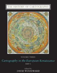
Woodward, a specialist in the early modern Italian map trade and Harley’s co-editor for the first two volumes (the second volume was actually three separate books on non-Western cartography published on a staggered schedule between 1992 and 1998), became the sole editor for this publication as well as the director of the History of Cartography Project run from his academic home base, the University of Wisconsin–Madison. Now halfway through six projected volumes, the History of Cartography series aims to be the definitive scholarly resource on the subject. The first three volumes are arranged not by alphabetical entries but rather contain thematic essays on conceptual, thematic, or localized trends. This might disappoint scholars searching for concise biographical sketches of major cartographers or in-depth studies of individual maps, but it provides a valuable and authoritative survey that such an atomized approach would lack.
A wonderfully erudite, insightful, and generous scholar, Woodward contributed substantial essays to the first and third volumes. Because this particular volume on the Renaissance has been in gestation for so long, a retrospective aura hovers over it, especially due to Woodward’s passing in 2004. (Jude Leimer, managing editor of the History of Cartography Project, oversaw its final production.) Among the sixty-four contributors to the volume, several others did not live to see its release: John Hale (“Warfare and Cartography, ca. 1450 to ca. 1640”), John P. Snyder (“Map Projections in the Renaissance”), L. A. Goldenberg (“Russian Cartography to ca. 1700”), and Cornelis Koeman (co-author of two essays on cartography in the Low Countries). Some of their chapters—among the more traditional in the volume—were written in the late 1980s or early 1990s, but have been updated with current bibliography.
The sixty-two essays in Volume 3 cover topics between the fourteenth and seventeenth centuries and span the entirety of Europe. In his introductory essay, “Cartography and the Renaissance: Continuity and Change,” Woodward concisely addresses the editorial compromise that defines this volume. The development of the printing press and the role of exploration emblematize why early modern European cartography has typically been defined by a “progressive model” (6) concerned primarily with increased accuracy and technical detail. Yet such a model, overwhelmingly focused on elite, state-sponsored cartographic production, not only ignores the great continuities persisting from late medieval maps but also excludes “the everyday artisan or map consumer” (7) and the fantastic, symbolic, and literary meanings attached to early modern maps. While still clinging to the fraught word “Renaissance” (“because it remains a useful practical term that is intuitively understood by many people” (6)), Woodward’s vision for the project takes great care to include both the technological and the cultural-historical rather than framing the period as an inevitable march toward increased cartographic accuracy.
In order to encompass all of these aims, the book weighs in at over 2,000 well-illustrated, thoroughly footnoted pages. The first tome offers wide-ranging investigations of the cultural meaning of maps, with topics ranging from pedagogy (Lesley B. Cormack’s “Maps as Educational Tools in the Renaissance”), to production (Robert Karrow’s statistical survey, “Centers of Map Publishing in Europe, 1472–1600”), to how cartography echoed in the period’s literature (Neil Safier and Ilda Medes dos Santos’s “Mapping Maritime Triumph and the Enchantment of Empire: Portuguese Literature of the Renaissance”). In this section stand side-by-side essays dealing with straightforwardly technical matters (such as Uta Lindgren’s “Land Surveys, Instruments, and Practitioners in the Renaissance”) and those addressing epistemological concerns (Pauline Moffitt Watts’s “The European Religious Worldview and Its Influence on Mapping”). The last three hundred pages of the first book and the entirety of the second fall under the heading “State Contexts of Renaissance Mapping.” While the national divisions are a bit unbalanced (Italy, France, Britain, and the Low Countries contain much more detailed coverage than Spain, Portugal, Germany, and Central and Eastern Europe), these essays lay out the patterns of production and consumption that varied so greatly around Europe.
At their strongest, the book’s essays can lay claim to encyclopedic thoroughness while embracing the paradigmatic shifts that have come to define cartographic studies in the last two decades. Peter Barber’s lengthy “Mapmaking in England, ca. 1470–1650,” for example, could have been spun off to become a stand-alone book in its own right, so far does it range through its subject and so complete is its bibliography. Patrick Gautier Dalché’s comprehensive “The Reception of Ptolemy’s Geography” clears up some of the musty legends associated with the subject (such as the now-discredited assumption that the translation of Ptolemy into Latin played a crucial step in the development of single-point perspective) and assesses the Geography’s arrival across Europe rather than just in Florence. The author of numerous French-language books of articles on late medieval world maps and nautical charts, Gautier Dalché here contributes in English what likely will become the standard and definitive essay on this much-studied subject.
In the second century AD, Ptolemy had defined geographical mapping as the realm of scientists and what he called chorography (or view-making) as purely an artistic pursuit. Although theoreticians of the fifteenth and sixteenth century continued to argue in support of Ptolemy’s point, in practice a number of new surveying instruments brought about great developments in how a view was put together. The new mode of representing cities that evolved in tandem with the popularity of print demanded both art and science. Art historians will thus want to read carefully Hillary Ballon and David Friedman’s “Portraying the City in Early Modern Europe: Measurement, Representation, and Planning,” which addresses an important point passed over in much of the rest of the volume: that maps and city views demanded increasing technical accuracy but also out of necessity involved conventionalized representational fictions for the sake of legibility and coherence. The bird’s-eye view, for example, typically employed an imaginary angle far beyond what any eye could possibly see from the highest spot around the city. The authors write, “The mapmaker’s core achievement . . . was to make an impossible view seem credible and to convert a picture riddled with lies and artistic inventions into a respected form of knowledge” (688). Schulz had made a similar point in his Art Bulletin article on Jacopo de’ Barbari’s ca. 1500 view of Venice, but Ballon and Friedman bring many more examples to bear on how such hybrid images were achieved and the balance between conventionalized and technical skills required to make such a view.
The limitations of the new volume are inevitable. Readers approaching it hoping to find images for study will need to jump around between the two books quite a bit, since some of the maps illustrated in one place are treated in multiple essays. Many maps under discussion could not be illustrated at all, owing to obvious space constraints, although they are usually easy to find online. Because more than half of this volume is divided regionally, some of the synthetic work linking or comparing cartographic production in various regions is lacking. One particular subject that deserves its own essay is the early modern development of the geographical atlas. Considering that Ortelius’s first edition of the Theatrum orbis terrarum (Antwerp, 1570) gathered the work of eighty-seven cartographers from all over Europe and was frequently updated and republished, it served as one of the signal cartographic achievements of the time. Although Ortelius is discussed in many essays, one wishes to see a more focused treatment of his achievement.
The University of Chicago Press deserves great credit for seeing such a mammoth project through over the last quarter century. The book not only is richly illustrated but includes helpful, at times lengthy, captions for its maps that succinctly identify their significance. Three more volumes will follow, charting the Enlightenment, the nineteenth century, and the twentieth century. Unlike the first three, a note in the introduction informs the reader, the upcoming volumes “are being planned as multilevel encyclopedias organized alphabetically” (xxxix). One hopes and expects that the rigor of this volume’s interpretive essays will be maintained in the new format.
Mark Rosen
Associate Professor of Aesthetic Studies, Edith O’Donnell Institute of Art History, University of Texas at Dallas

